Tag: East Fork San Gabriel River

Gather ’round the Poop Tree

True love is picking up used toilet paper from the infamous Poop Tree in the Monument with a bunch of other FRVC volunteers. It’s not nearly as fun as it looks, but hanging out with the other volunteers is a blast.

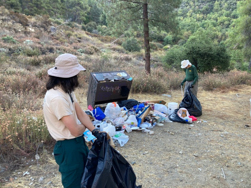
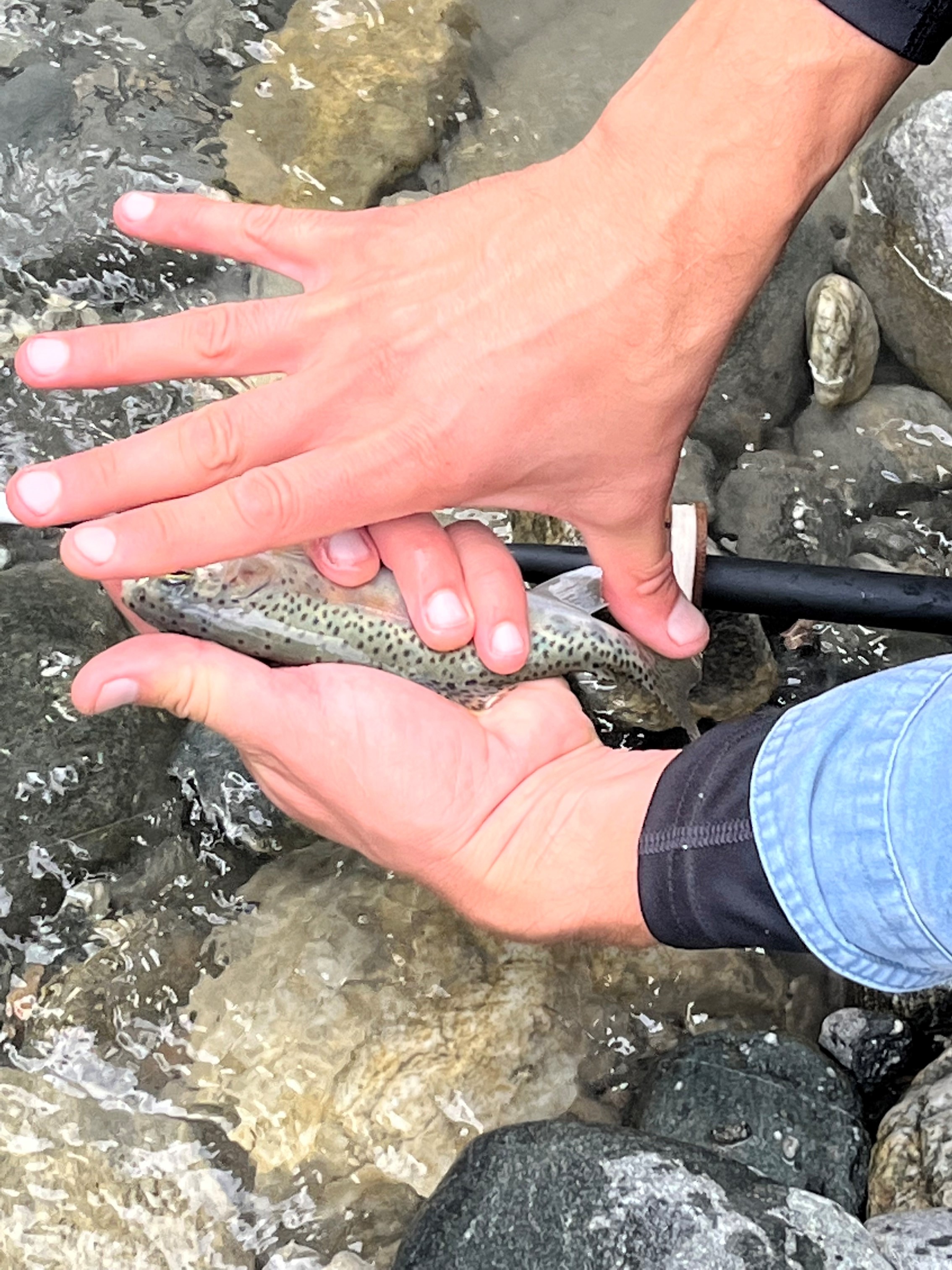
Last week, I logged my last Fisheries Resources Volunteer Corps mission. About a dozen of us began at 7 a.m. and completed the Total Maximum Daily Load measurements at four different spots by 2:30. We skipped lunch because we all wanted to “get ‘er done” and the temperature was hot as blazes in the San Gabriel Mountains National Monument. Plenty of sunscreen couldn’t hide the true grit of this group. It’s nasty, hot, brutish work.

For a TMDL survey FVRC volunteers record all the garbage by category and by pound within a 100-foot stretch of what should be pristine water flowing from Mount Baldy into the East Fork of the San Gabriel River. A TMDL was my first patrol last year and I couldn’t believe how positive these folks were about a dire situation. After all, who can say that they actually had fun cleaning up human waste, plastic bags, dozens of straws, discarded socks, kids pool toys, cigarette butts, beer bottles galore, in other words all the leftovers from those who visit our Monument and should know better than to leave it all behind.

Each time we go out, we dutifully bag several hundred pounds of consumer society’s discards, lug them uphill from the stream, weigh each bag, then drive the bags to the dump. I joked with Craig, a dedicated volunteer, about what a good time we had doing this and he said,

“Yup, my friends ask me if I’ve done something wrong? If that’s why I’m out here collecting garbage.”

If you knew Craig and his daughter, Haley, you’d realize all they seem to do is what’s right.

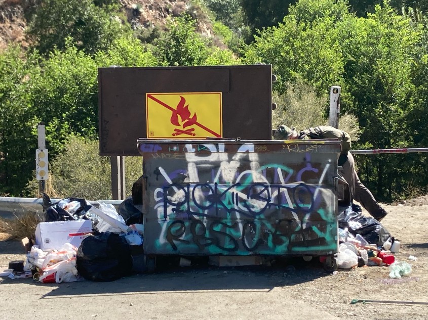
Each year, FRVC forwards the survey of how many pounds of soft plastics, hard plastics, threats to human health and all the other TMDL categories to the Forest Service. I think this is the second year of of three year study, but don’t quote me. At the end of the study, the powers-that-be will be able to ascertain what anyone on one of these patrols–as well as anyone visiting the East Fork during summer– already knows: we are overrun with garbage, graffiti, illegal stream dams, fire rings, illegal parking and all the rest of it.

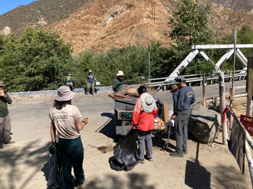
That’s why I was particularly heartened to hear from a Forest Service employee who also volunteered that day; there are plans by the FS to actually take action. One idea is to designate parking spaces that would be accessed by a reservation system. Your car would get a numbered parking spot for the day that was just for you and nobody else.

Sounds familiar, right? Parks and camping areas all over California use the same fee-based system. Then—very important—there would be enforcement from the Sheriff’s Department or the California Highway Patrol. In all the years I’ve fished the Sab Gabes, I’ve never seen a cop give anyone a ticket for anything.

Another idea is to create a kiosk and gate where visitors would stop and pay a fee for the day at the nearly invisible Visitors’ Center at the start of the canyon on Hwy. 39. Again, this is a system anyone who visits our state parks is familiar with: You pay a fee, get a map and speak with the rangers to get oriented.

Or both might be implemented.

The point is that even though implementation will require wading through layers and layers of bureaucracy and a public review before we all see any changes, it seems the FS is finally taking notice that the status quo can’t continue.

As a concrete example, expect to see a net stretched downslope of the bridge before the East Fork parking area in the near future. That’s a direct result of the monthly TMDL studies that FRVC carries out. Who knows if it will keep the hundreds of pounds of summer trash out of the water, but trying solutions, even when they fail, can lead to more and better remedies.

See you on the river, Jim Burns

The source makes a difference

This is where the forks flow into the main San Gabriel River, behind the earthen San Gabriel Dam, which is currently dry. Note the difference in color between the East Fork, on the left, that flows from Mount Baldy, at 10 ,000 feet, and the West Fork that flows from Cogswell Dam. (Credit: Jim Burns)

Back-to-back wet years = wow

THE WEST FORK was rolling today! I even went for an unintentional swim, so, dang, be careful out there! (Credit: Jim Burns)
THE EAST FORK in early May, 2023. The rains gave us fishing fanatics a whole year of wonder. (Credit: Jim Burns)

East Fork continues to produce quality ‘bos

No, Martha, it’s not Montana, it’s the East Fork!

If you missed the “Martha” reference in the title, it’s just because you are young and never had the pleasure or — whatever — of working in legacy news, when there was such a thing.

A “Hey, Martha” story was offbeat or odd, as in, “Hey, Martha, didya hear about the cat who solved the Rubik’s Cube — with no hands??”

Yes, before there was click bait, there was the “Hey, Martha.”

Anyway, inspired by a recent video of clear, fast water on the West Fork (and very bummed that the weekday ban for using the bike path has been extended to December), I ventured to the East Fork. I basically couldn’t believe my eyes: white caps, swells, skinny trails swallowed by water.

In fact, check out this video. If you recognize the area on the right as your old path up to your fav spot, it’s gone. As is the hole where a friend got me into a wee trout last season, my first time at the EF after miners. I would bet all of your favorite spots are now gone — and, never mind, it is glorious to behold this much water flowing freely down the river. New favorite spots with either be discovered, or reappear as fishing season approaches.

Bonus: Who knew our local mountains were this beautiful! Green brings out their canyons, their crevasses, and — their waterfalls.

See you on the river, Jim Burns

Readers’ Comments on the state of the San Gabriel River

LOW WATER behind JPL during summer, 2021.

After all this clobbering rain, I’m sure many local fishers are anxious to see what the mountain tributaries of the San Gabriel River have to offer, as we head into spring.

Water right now is racing, one friend describing what he found on the lower East Fork as “like a 10 or 20-year flood.”

Here are a few comment from both before and after the rains.

Any scouting reports are always appreciated.

See you on the river, Jim Burns

November’s thankfulness

Many years ago. Maybe 20-30 years a huge El Nino did an amazing flush of the East, West and North forks. Fishing was amazing for a long time after that. Sadly, I think the recent rains, even though a flushing event, just will not be the same as 30 years ago. Maybe the East fork will benefit. I will venture forth in May but I am afraid of what I am going to find. I long to revisit those wonderful days that we took for granted but I am 78 now and fear that I don’t have enough time left to ever again see it like it once was. —
LARRY PIRRONE

November’s thankfulness

A friend went to another river in our local mountains and said all the normal pools were filled with sand and silt. It was not in a fire burn area. Our theory is that the rains a few weeks ago were just enough to dump sand in, but we need more rains to scour it back out. — Steve

 East Fork SOS: Where Have all the Fish and Anglers Gone?

Lousy. Thanks for sharing those depressing stats.
Consistent with my experience on East Fork too. Last trip was in 2014, here:

No trout. — Izaac Walton

 East Fork SOS: Where Have all the Fish and Anglers Gone?

WRONG. I just thru-hiked from Vincent Gap to the Bridge TNW trailhead and I caught three trout along the way fly fishing with a nymph. The first at Fish Fork, a tiny and beautiful purple rainbow. The second down about a mile, about an 8 inch rainbow, and the third was up north of the Narrows and this 12″ beauty fought like an 18 inch Sierra trout. STRONG fish up there, you just need to know how to fish and what to use. — Brendan Bordato

After so many deadly fires, every plume of smoke menaces

After I ate lunch, I got back to the parking lot and a plume of thick smoke, which looked to be right at the narrow bridge to the East Fork parking lot. My heart started racing, so I hopped in my car and drove as fast as I could. Sure enough, there was a very hot brush fire at that location. I asked the bystanders if they’d called 911. “No signal.”


I continued to race down to Azusa to make the emergency call, but, mile after mile, still didn’t get a signal. Also, my “emergency” cell coverage didn’t work. Such a relief when the first green forest service emergency vehicle sped by me, lit up, going in the opposite direction. I never realized it until today, but my cell reception doesn’t happen until I am entirely out of the canyon, even past the subdivision. As our Southern California traditional fire season begins, that is a cautionary tale. (Credit: Jim Burns)
Infrared imagery, taken by aircraft this morning, Friday, Aug. 26, reveals the hottest sections of the #EastFire.  The brush fire in the Angeles National Forest in the East Fork/Glendora Mountain Road area, is estimated at 149 acres with 20 percent containment. There are no evacuations or structures threatened. Very little smoke is coming from the fire today. County road closures in the area remain in place Glendora Mountain Road from Glendora to the East Fork Glendora Ridge Road from Mt. Baldy to Glendora Mountain Road SPECIAL NOTE: San Gabriel OHV Area will be closed this weekend due to fire operations nearby.(Credit: U.S. Forest Service)

East Fork SOS: Where Have all the Fish and Anglers Gone?

By Tom Walsh
President, Fisheries Resource Volunteer Corps

Repetitive comments from anglers, who have fished the East Fork of the San Gabriel River over the past five years, have indicated that there are no fish left. Based on 1,261 CDFW Angler Surveys over the past 15 years, anglers reported catching 10,901 fish. However, during the past five years only 777 fish have been caught, with only 11 being caught in the past two years.

What are the reasons for this significant decrease? Over the past five-to-12 years there are a number of events that have contributed to the loss of this fishery:

— 2005 – Twelve-year drought reduced total rainfall by 43.6 inches (3.6 inches/year) below 140-year season average.
— 2008 – Downturn in the economy brought an increase in encampments to the East Fork backcountry.
— 2008 – Price of gold hit all time high increasing from $769/oz. in 2007 to a high of $1,987/oz. in 2011.
— 2008 – Began removal of 20,000 tamarisk plants (One plant consumes up to 200 gallons of water per day)
— 2010 – California Department of Fish and Wildlife terminated fish plants on East and West forks to abide with court ruling.
— 2014 – High rain event on Aug. 3 bought significant amount of sediment downstream with large fish kill.

Of all of these events, the mining activity has been the most damaging, which has increased significantly, with the rise in gold prices, the promotion by mining guides via social media and the lack of enforcement of the mining prohibition.

The negative impacts to the stream and its riparian areas resulting from the mining activities are numerous. Large amounts of material in the stream and riparian areas are being moved to create dams, dredging holes and long diversion channels for sluicing, resulting in heavy silting, reduction in water flow and the interruption of the entire ecosystem. FRVC volunteer stream patrols have documented the loss old growth trees along the stream banks, permanent campsites within 50 to 100 feet of the stream, large amounts of equipment and trash from abandoned campsites, and the use of motorized dredging equipment.

In October 2010, the California Fish and Game Commission designated the East Fork from Heaton Flat to the headwaters as a Wild and Heritage Trout Stream. This designation includes 33.6 miles of perennial stream habitat, and is one of only 12 watersheds in the state with this designation. Unfortunately, the CDFW management plan has not been published or implemented.

This once-prominent fishery, which has been abandoned by almost everyone, needs the support of the Southern California fishing community.

Calendar Item: Help clean up the East Fork

unnamed

Will East Fork again become vulnerable to suction dredging?

screen-shot-2017-01-21-at-4-13-17-pmFellow anglers,

In a political time, it’s once again time to get political.

If you thought that suction dredging mining was banned for good from the East Fork of the San Gabriel River outside Los Angeles, and other once-pristine California waters, think again.

You can read my coverage from 2012. I thought it was a done deal that the California Department of Fish and Wildlife would be allowed to stop illegal activities even on federal lands, even within a national monument. But Pasadena Casting Club Conservation Chair John Tobin recently alerted me that, sadly, it might not be the case in the future.

As Tobin wrote in an email, “California Senate Bill 637, effective January 1, 2016, created a path for the statutory prohibition against suction dredge mining on our California streams to be lifted.”

Currently, there’s a case before the California Supreme Court challenging whether state environmental law that makes a particular mining claim on federal land commercially impractical preempted by the federal mining laws, according to the brief.

In other words, can California through its police power protect the environment, even on federal land?

For anglers, this means a choice between antiquated, destructive machinery disrupting the stream bed and scattering whatever trout may have thrived there for a largely recreational activity. Imagine trying to wet a line next to one of these contraptions. Imagine the downstream effect to the water.

north-fork-redeker-dredging-070707-dredge-plume_upper-american-river-fdn
Can you imagine trying to fish downstream from this suction dredging mining operation? (Photo courtesy of Trout Unlimited.)

You can lend your voice either at Trout Unlimited  on suction dredging issue or at Friends of the River alert on suction dredging.

You use our national lands to enjoy one of the best parts of your recreational life. Help make suction dredge mining a thing of the past.

See you on the river, Jim Burns