After I ate lunch, I got back to the parking lot and a plume of thick smoke, which looked to be right at the narrow bridge to the East Fork parking lot. My heart started racing, so I hopped in my car and drove as fast as I could. Sure enough, there was a very hot brush fire at that location. I asked the bystanders if they’d called 911. “No signal.”
I continued to race down to Azusa to make the emergency call, but, mile after mile, still didn’t get a signal. Also, my “emergency” cell coverage didn’t work. Such a relief when the first green forest service emergency vehicle sped by me, lit up, going in the opposite direction. I never realized it until today, but my cell reception doesn’t happen until I am entirely out of the canyon, even past the subdivision. As our Southern California traditional fire season begins, that is a cautionary tale. (Credit: Jim Burns)Infrared imagery, taken by aircraft this morning, Friday, Aug. 26, reveals the hottest sections of the #EastFire. The brush fire in the Angeles National Forest in the East Fork/Glendora Mountain Road area, is estimated at 149 acres with 20 percent containment. There are no evacuations or structures threatened. Very little smoke is coming from the fire today. County road closures in the area remain in place Glendora Mountain Road from Glendora to the East Fork Glendora Ridge Road from Mt. Baldy to Glendora Mountain Road SPECIAL NOTE: San Gabriel OHV Area will be closed this weekend due to fire operations nearby.(Credit: U.S. Forest Service)
Better times on the West Fork, before the Bobcat Fire virtually destroyed this beautiful fishery. (Jim Burns)
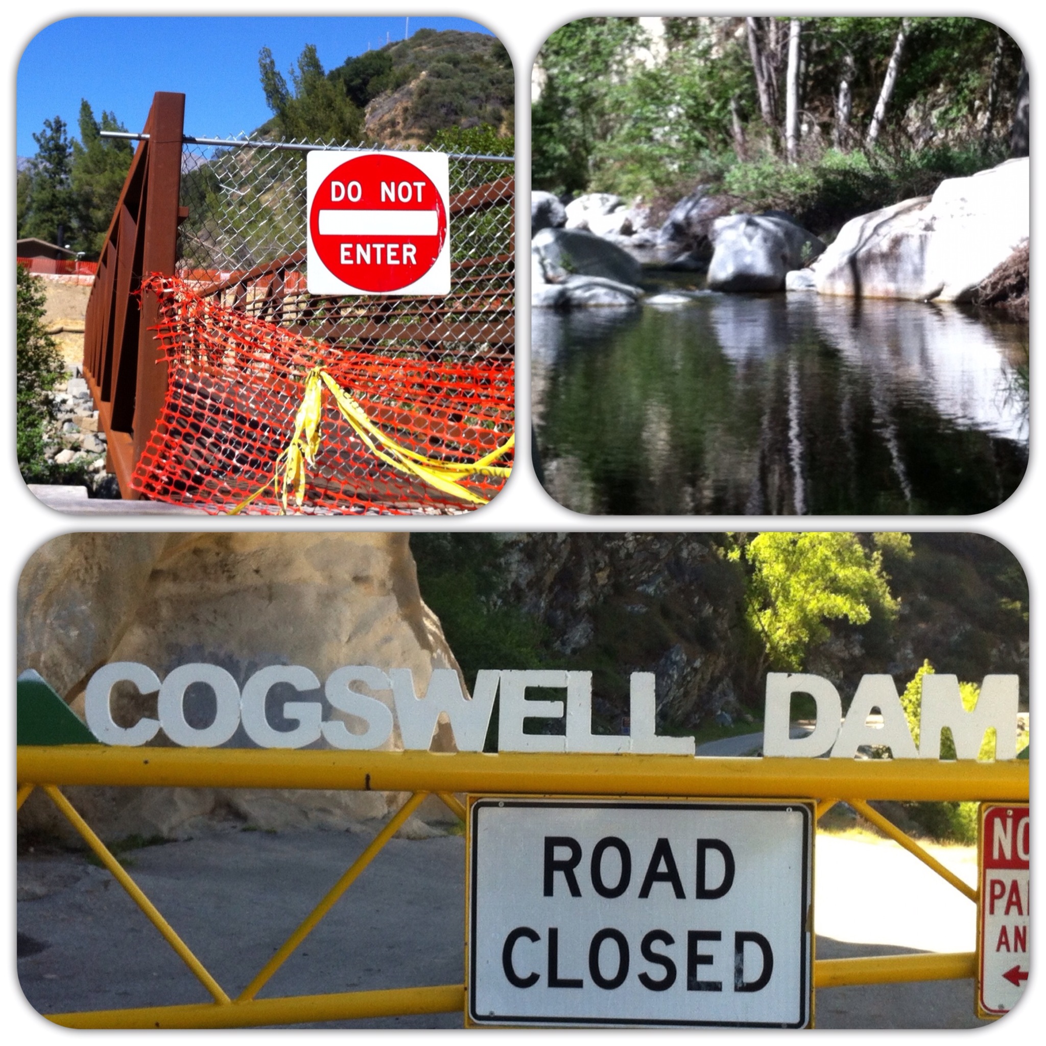
Update: March 30, 2022 — The official response is the West Fork will remain closed indefinitely. The unofficial intel is the four disabled fishing ramps are submerged in mud and debris, and unusable at this time. Crews will be working to clear these areas as well as the bike path to Cogswell Dam. At some point, the area will reopen during weekends, but be closed during weekdays. Stay tuned.
Letter to the Editor from California Fly Fisher: I much appreciated Jim Burns’s story on the West Fork of the San Gabriel, which did a good job of capturing the character of a place that I have been visiting for decades. (“The West Fork of the San Gabriel,” September/October 2020.) Unfortunately, shortly after the issue came out, much of that river’s watershed was reduced to charcoal and ash by the Bobcat Fire.
By the way, readers of Cal Fly Fisher might like to know that the Oct. 13 issue of the Los Angeles Times has a great article on the ecological devastation wrought by the fire, and it noted that the river also faces additional harm from mud flows when the rains of winter arrive. That’s a helluva one-two punch against this little fishery. Only time will tell whether it has been KOed for keeps — Fred Martinez, Los Angeles.
A typical hand-size rainbow from a trip I made in May to the West Fork. (Jim Burns)
Dear Fred,
Thanks for the props. I loved the West Fork, as I can tell you did. I thought you would appreciate this update from John Clearwater, a public affairs officer with the U.S. Forest Service:
In the course of four major fires we lost 23-percent, or nearly a quarter, of the Angeles this year. To include some of our most beautiful areas. It’s been a tough, heartbreaking year.
Regarding the closure of the West Fork, the Bobcat Fire closure area extends to April 1, 2022. I don’t anticipate that the West Fork will reopen much sooner than that.
I was in there a few weeks ago with LA Times reporter, Louis Sahagun. The area is near the origin site for the Bobcat Fire, and one of the areas that was most impacted by the Fire.
Unfortunately, much of it now looking like an ashen lunar landscape. It was clearly once a mountain paradise. Now it’s heartbreaking to see. This winter I suspect the road may disappear in a number of places due to the lack of vegetation and likelihood of runoff coming down the mountainsides. During my time in there recently we encountered a number of rock slides breaking loose, rolling off the cliff tops and impacting onto the roadway, with rocks varying in size from that of a baseball to a soccer ball. Any of which would have been fatal if it had struck someone on the head.
Regardless, there is much work that will be required in the West Fork for public safety, forest recovery and habitat protection.
As for plans for the trout in the West Fork, I’ve spoken with the District Ranger team and they said the California Department of Fish & Wildlife is planning to soon relocate a number of trout from the West Fork to other areas of the San Gabriel river. They could not provide a lot of details.
HANDY MAP: The National Forest Service helps you to get oriented once you finally find Deep Creek. (Jim Burns)
UPDATE: Take Deep Creek off your fishing radar until the drought ends. You’ll find little water and few fish. Also, because this is a protected area, if the native fish die out, that will also be the end of this once beautiful water because it won’t be stocked. Don’t add to their stress by catching them.
Weather and fate are tied together.
Two winters ago, So. Cal. was literally awash in water, and so was Deep Creek, high in the mountains above San Bernardino. Those 18-plus inches helped to carry this once-cherry spot back to the near-top of many an anglers’ list. My last visit was May, 2011, which I chronicled here.
So wondering what our sub par rainfall for the year just ended (6.97 inches, June 30) did to the place, yesterday I jammed the hour and a half from my house to Lake Arrowhead, thinking that “lucky Monday” would apply, even in summer. Any fly fisher can tell you that Mondays are the best time to avoid all those other folks, some with waders on, lots without, who want to hike, swim, bike, laze, and generally cavort on our public lands. But sometimes that Monday luck runs out.
Sure enough, on a hot, windy gust the “whhhhiiiiinnnneeee” sound of a dirt bike engine greeted me, as I managed to find a parking spot among the dozen cars and one RV at the end of the road. It was just shy of noon as I rolled down the windows, ate a home-packed lunch, then — because I’m an optimist — inaugurated my new waders, even though the mercury was fast approaching 90 degrees F.
Thusly cocooned, I trudged past a nice grandfather and family, boots feeling way too big and clumsy for the heat. From his lawn chair in the shade, he looked me up and down, saying, “You think there’s enough water to catch a trout?” He quickly realized I was on my way in and didn’t have a clue. I grimaced, hoping he hadn’t just inadvertently given me one.
After spending about four hours systematically working my way around the semi-circle of water that surround the Splinters Cabin, down to the beginning of the canyon, all I can say is, unfortunately, Deep Creek’s done for the season. The water is fishable, true, but the fish are few, small and not ready to believe your newly tied midge is anything but a bunch of wire and fixings. Also, true, that on the last hole I lost a nice fish because I forgot that a log has two sides, and I was on the wrong one. Equally true, I fished a 7-weight leader for the little guys, which he easily broke with the log’s help.
For the rest of this long, hot summer, if you are more of an optimist than I, a party of three young guys who I think had just escaped from a scene in “Sucker Punch” told me that they’d spotted large fish much deeper in the canyon. I was done after losing the only good fish of the day, and didn’t follow their advice. Instead, I stripped off the waders and had a great time splashing my bathing-suit way back to the car, almost as free as a child until “whhhhiiiiinnnneeee” again reached my ears on hot, gusts, while I panted my way over the last hill.
From dirt, to pock-marked asphalt, to the mountain-lip-hugging Highway 18, I couldn’t shake that eerie sound memory of straining machine, amplified by the wind. Then, suddenly, my fear realized, I saw plumes of smoke rising hundreds of feet from the distant San Bernardino valley. Scattered orange cones closed the 18. I stopped in front of a CHPS officer who told me how to thread my way onto the 138, to connect with the 15, then home. Tiny Arrowhead-adjacent Crestline was under a voluntary evacuation. Officials would later dub the brush fire, “the Panorama Fire,” which has burned 75 acres as I write and is still burning.
As Henry Wadsworth Longfellow reminded us long ago, “through woods and mountain passes, the winds, like anthems, roll.”