So, if you asked me, “hey, Jim, did you have the work week from hell?’ I’d pretty much say, “yup, and goodbye to all that.” Because today is Saturday. And Saturday was custom-made for fishing, just like a sweet, summertime mint julep.
Why have a workweek gloom-over when my calendar read: FoLAR Citizen Fishing event, 2 p.m.
And isn’t citizen fishing just really a wonderful excuse to fish for the best cause (science), jaw-bone with old friends, meet new ones, and be in awe (I know I am) of both Rosi Dagit and Sabrina Drill, the biologists who keep mining our river for fishy clues? And a shout out to FoLAR’s Bill Bowling, organizer extraordinaire, and to Trout Unlimited’s Bob Blankenship.
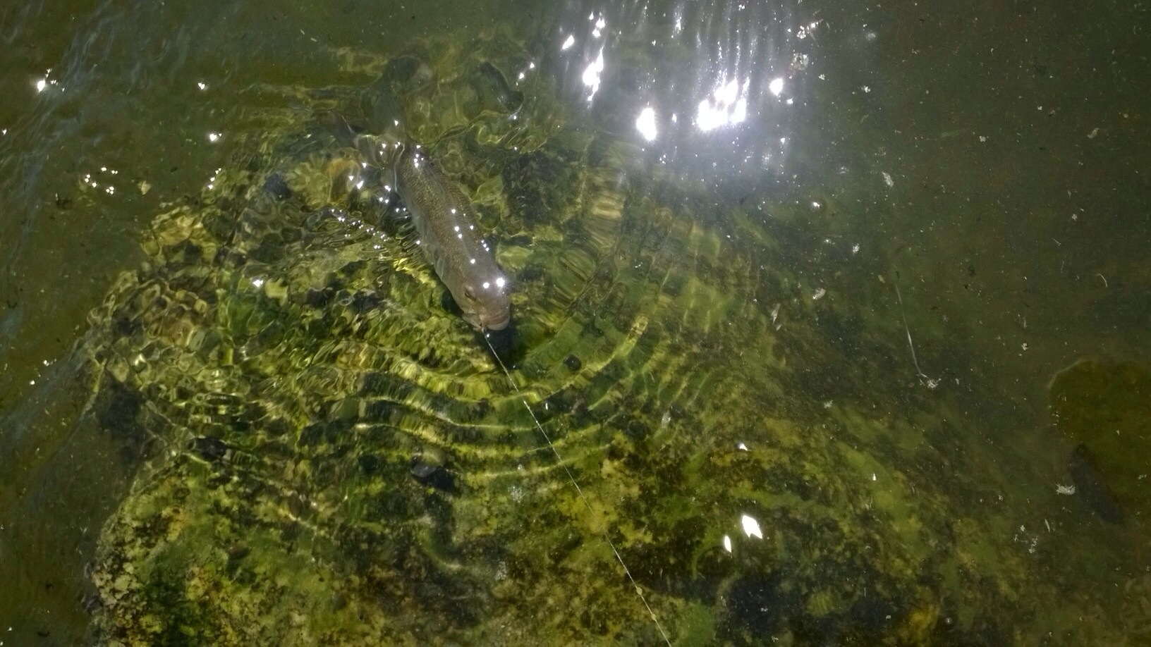
So this marvelous (hot) Saturday afternoon, about a dozen anglers and assorted others all met to continue the conversation of what the heck is in the river in Long Beach. Observers could tell something was up from the telltale Home Depot orange buckets that lined the bank. No mullets, nor smelt. Today’s puzzle pieces: a 5-pound common carp and a slightly smaller mirror.
And it is on days such as this one that I count
DRIPPING WET: Todd Suttle pulled in this common carp on a tortilla fly. He also found a dollar bill. (Jim Burns)
my blessings to have many riverly friends, and feel connected to something truly awesome.
Lends new meaning to the phrase, “Up against the wall.” (Roland Trevino)As the first-ever Off Tha’ Hook derby approaches, bass and tilapia are very catchable, while carp are a no-show. At least that’s what we’ve found over a couple of mornings of fishing these past two weeks. Believe me, the water is downright hot by midday, wet wading feeling at times like we were back home in our bathtubs.
Last week, LARFF guest contributor Roland Trevino brought his son, so this time I got to bring mine. Their age difference is only a matter of two decades.These little bass have been around and very catchable on our last two outings. (Roland Trevino)
Will hooked up on a couple of small bass, which had green sides instead of the whiter version we’d caught last week. Bass are now fairly abundant in the Glendale Narrows stretch, which is a far cry from the lonely one caught in the Friends of the River fish study in the later 2000s. It’s a great story and one maybe a commenter can help us to untangle. How are they getting into the water? And what’s with the white body color we’ve seen?
Little fish, big fun. (Roland Trevino)Also, yesterday, we spotted hundreds and hundreds of tilapia fry by the banks. I hooked up on what I believe was an adult tilapia but got hung up in the rocks.
The first book published by Aquarium of the Pacific in Long Beach details the struggles of the endangered Southern California Steelhead. (With permission, Aquarium of the Pacific)If you think you’ve finished your summer reading list, stop! Consider one more book, please.
“Against the Current, The Unlikely Story of the Southern California Steelhead” could not, in truth, be a more unlikely tale. Author John G. Tomlinson Jr. takes the reader on an environmental roller coaster ride that matches our region’s boom-or-bust water supply, and throws in plenty of human Greek drama.
What just over a 100 years ago was a region so pristine that Easterners came here to mend their health, through hunting, fishing and soaking up the sunshine, quickly turned into what we have today. As someone who has lived here for over 30 years with no plans of leaving, I’m not complaining, but when you read this book and realize what it once was — especially if you enjoy fly fishing the San Gabes — well, get our your handkerchief.
Sob.
One fact to prime the tears: In the early 1900s, the then-equivalent of the California Dept. of Fish and Wildlife set the limit of fish taken at … 100. If you’ve ever put boots to dirt and fly to water in our mountains, this should give you a chill. Guests at the local fishing camps regularly hauled in lots of rainbows, and, yes, steelhead. And they hauled, and they hauled and they hauled. Think buffalo in the plains states.
How we got from those abundant fishy beginnings to where we are today is a story of good intentions gone to greed, it’s about that simple.
As for the steelhead once again taking center stage as we enter the Great Los Angeles River Rebuilding, well, this magnificent creature needs our help to get off the endangered species list.This chart of the comparative rainfall might not look great during our record-breaking drought, but in earlier times, it was a draw for those looking to escape bad weather and regain their health. (With permission, Aquarium of the Pacific)
When Congress approves the billion bucks for a river makeover early next year, I hope every politician, every engineer and every investor gets a copy of this book. They should look up the section on one Henry O’Melveny, lawyer, fishing advocate, Creel Club founder, ice plant owner and, sadly, leader of the pack that done the natural inhabitants of our erratic rivers and streams in. Indeed, he is a figure as defining of Greek tragedy as Oedipus or Agamemnon.
Fast forward to today, and a mayor who is bringing in major bucks from Washington for the river as well as public transportation. I hope that Eric Garcetti reads this slim volume. It is the most compelling work to date on why the natural habitat can’t take a backseat to our own urban comfort zone. That story already happened.
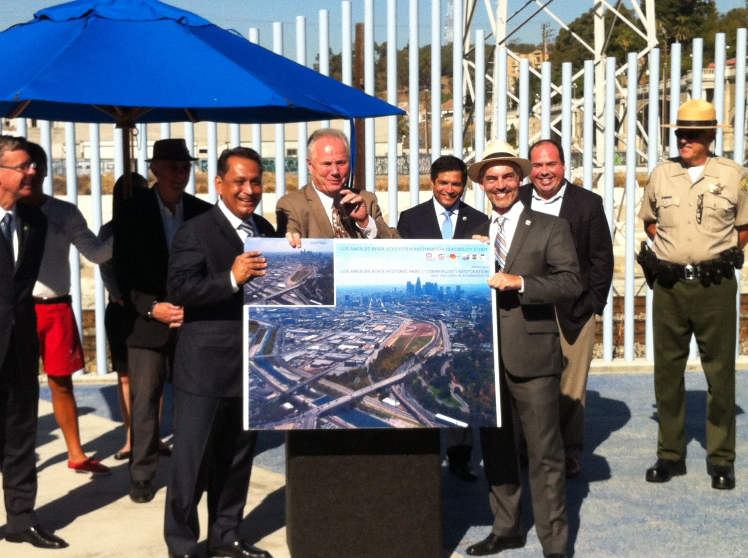
Pushing for the billion-dollar restoration option, from left, are councilmembers Cedillo, LaBonge and O’Farrell. in the center, back, is California State Assemblymember Jimmy Gomez (D., 51st District) (Jim Burns)
In preparation for what could be remembered as an historic city council vote, three councilmembers made their case poolside for the most expensive restoration of the Los Angeles River at over $1 billion. It was a continuation of a public relations campaign over the summer to convince Washington to open its strained pocketbook in favor of a local project with considerable political capital.
The press conference, strategically held at Downey Pool, close to both the river and Los Angeles State Historic Park, presaged the first time since 2006 that the city would declare its priority publicly. Ironically, its partner, the U.S. Army Corps of Engineers, didn’t attend.
“I think you’re going to see an unprecedented push and an unprecedented effort of collaboration. We are dead serious about this, and we are aspiring to work together, to collaborate, to pool all the resources, working with the state, but also preparing to go to Washington, working with the Army Crops of Engineers to get the biggest package that we can for the city,” said newly elected Councilmember Gil Cedillo.
He, together with council colleagues Mitch O’Farrell and Tom LeBonge, made it clear that the city wants the federal government to spend $1 billion over the next several years to restore the Los Angeles River to at least a semblance of what it once was, as will be outlined in the Corps’ Los Angeles River Ecosystem Restoration Feasibility Study (ARBOR), which cost $10 million and seven years to complete.
Even though the actual study, along with its four restoration alternatives, won’t be released by the U.S. Army Corps of Engineers until Sept. 20, politicians and river advocates are lining up in support of the most expensive plan. After ARBOR’s release, there will be a 45-day public comment period and a public meeting on Oct. 17. Although a month away from the report’s official release by the Army Corps., the broad outline has been available for weeks.
A few hours later, the Los Angeles City Council voted unanimously “to endorse a Los Angeles River Ecosystem Restoration Feasibility Study alternative that results in the most expansive ecosystem restoration.”
Last week, Los Angeles Mayor Eric Garcetti sent a letter to Washington advocating for the same thing.
“The ARBOR study Alternative 20 will begin to reweave the city and the watershed together,” said Lewis MacAdams, who established Friends of the Los Angeles River, and is now considered the “grandfather” of the current restoration effort. “It will bring the river together with the mountains, and it will bring the people together with the habitat, miles of concrete will be destroyed. It would begin to payback with this billion dollars all the work that’s been done to destroy the L.A. River.”
MacAdams recounted how, as an old-time Army Corps of Engineers fighter, he was surprised to be invited to a teleconference between the L.A. District and the national headquarters in Washington a couple of months ago. He went on to say he was shocked when I saw what was going to become the proposal of the L.A. district, Alternative 20.
By contrast, Alternative 13., said to be favored in Washington and the least expensive of the plans, has a projected cost of just under $450 million to pull concrete and make other habitat changes along the 11 miles of the river from downtown to Griffith Park.
“We’re Los Angeles. We deserve a $1 billion investment in the Los Angeles River. We’re going to fight for this,” O’Farrell said.
FOR IMMEDIATE RELEASE: June 14, 2013
Media contact:
Scott Johnson, Metrolink Public Affairs
(213) 452-0205 or johnsons@scrra.net
Metrolink to conduct health risk assessment of maintenance facility
LOS ANGELES — Metrolink Chief Executive Officer Michael P. DePallo announced today he has directed staff to immediately commence preparations for commission of a health risk assessment (HRA) of the agency’s Central Maintenance Facility located at 1555 N. San Fernando Road in Los Angeles.
“This is a significant step to quantify the emissions emanating from the facility and to solidify a baseline,” said DePallo.
Metrolink Board Chair and San Bernardino Mayor Pat Morris agreed.
“As the mayor of the city that hosts the largest intermodal rail facility in Southern California, I understand the concerns of those who reside near Central Maintenance Facility,” said Morris. “I, as much as anyone, want to know the results of this assessment, along with the subsequent measurement of the air quality improvements we have already made to the facility.”
Metrolink has worked extensively with community groups, key stakeholders and elected officials over the past two years to implement a wide array of facility and operational improvements.
Metrolink made a major contribution toward improving the quality of the environment and future rail system operations with the purchase of up to 20 new low-emission Tier 4 locomotives. These locomotives produce more than 80 percent less particulate matter and oxides of nitrogen than current older engines and will be delivered in late 2015. Metrolink has allocated $129.4 million for the purchase of the locomotives.
The locomotive upgrades will have system-wide benefits, and as well as help reduce emissions in the surrounding communities.
At the facility itself, Metrolink has implemented a plug-in policy that enables trains to utilize ground power while being cleaned and serviced instead of utilizing the engines that power the passenger cars. Nine ground power stations have been installed, while the facility anticipates an additional four stations being built this year.
Metrolink has installed Automatic Engine Start Stop (AESS) technology into its locomotives and implemented an aggressive fuel conservation program. AESS is a mechanism that prevents unnecessary idling, reducing fuel use and emissions. In 2010-11 AESS reduced the amount of fuel used from the previous year by 860,000 gallons and saved the agency $2 million. Currently 33 of Metrolink’s 52 locomotives are equipped with this technology.
In order to reduce noise at the facility, train maintenance, servicing and testing is done during business hours to avoid disrupting sleep and weekend recreation activities. Additionally, staff has reduced the amount of time trains are on service and inspection tracks by 50 percent.
Without Metrolink service, an additional 18,000 vehicles would be on the roads each weekday.
A health risk assessment (HRA) is an analytical tool used to estimate whether current and/or future exposures to certain air pollutant emissions will pose health risks to a broad population, such as a city or a community.
The CMF, which is located on a parcel of what once was referred to as Southern Pacific’s Taylor Yard, has been a rail facility servicing locomotives and rail cars since the 1920s. Metrolink began servicing trains at CMF in 1991.
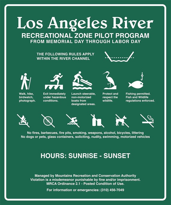
After lots of public input, wrangling over dogs (don’t bring them …) and some bureaucratic close shaves, the Los Angeles Recreational Pilot Program is on for the summer.
Signs such as this one will inform visitors to the two-and-a-half mile stretch of water (Courtesy MCRA)
“For the first time since the Los Angeles River was channelized in the 1930s, the public will be welcomed to walk, fish and kayak on a 2.5 mile portion of the L.A. River in Elysian Valley. The Mountains Recreation and Conservation Authority (MRCA), in cooperation with the City and County of Los Angeles, the Los Angeles County Flood Control District, and the Army Corps of Engineers, will administer the historic Los Angeles River Recreation pilot program to increase safe public access to the L.A. River and to promote the goal of river revitalization. The recreation zone includes the river channel and five feet of adjacent riverbank—but not the upper banks or the existing bike path, or the maintenance road on the banks above the river channel.
“The program runs from Memorial Day (May 27) to Labor Day (Sept. 2) and from sunrise to sunset daily, during safe conditions. During this time, any member of the public can access the Recreation Zone free of charge. Organized groups and fee-based groups must obtain special use permits from the MRCA for which there is a fee. Boat access to the Recreation Zone is located at MRCA-managed Rattlesnake Park at Fletcher Drive. The exit point will be downstream adjacent to MRCA-managed Steelhead Park on Oros Street. MRCA Rangers will regulate usage and promote public safety in the Recreation Zone with rules established by the MRCA ordinance. The Recreation Zone also permits activities such as walking, bird watching, and fishing (with a California Department of Fish and Wildlife permit). No dogs are allowed in the Recreation Zone. Foot traffic is strictly limited to paved and rocky surfaces in order to protect protected bird habitat.”
PADDLE UP: The L.A. Conservation Corps guides a group through still waters and overhanging willows. (Jim Burns)
The Los Angeles City Council voted yesterday to approve the first recreational zone on the Los Angeles River.
The motion passed in an amended form over the objections raised in public meetings about adequate neighborhood parking and the rights of dog owners to walk their pets along the river’s bank in the defined area. Beginning Memorial Day through Labor Day, riverside residents, as well as visiting kayakers and others, will judge how successful, or lacking, the program is.
It was a clear victory for Councilmember Ed Reyes’s office, which looked to expand the recreational use of the river after the success of last summer’s Paddle the L.A. River program farther north in the San Fernando Valley. Expect signage, provided in collaboration with KCET, a shuttle to get kayakers from parking near Confluence Park to the put in, and, finally, a single entity, the Mountains Recreation Conservation Authority, to enforce the rules, instead of L.A.P.D. Also, expect the MRCA to be looking for a valid freshwater fishing license if you’ve got a rod in the water.
Although generally supportive of the zone, the Department of Fish and Game remains cautious going forward.
“In general, yes, we would support the recreational zone, but the devil is in the details, senior biologist Dwayne Maxwell said via email. “The development of a recreational zone has the potential to improve some of the habitat characteristics of this reach of the Los Angeles River. We are having some difficulty, however, seeing this water as a plantable trout water. The number of exotic fish species and the potential high bank and water-oriented uses of the river probably would not make it a high priority sport fishing water.”
The amendments included:
— Clarify that the pilot recreational zone program consists of the ElysianValley area south of Fletcher Drive, from Rattlesnake Park to Egret Park;
— Recognize that the Mountains Recreation and Conservation Authority (MRCA),the U.S.Army Corps of Engineers, the Los Angeles County and the City have mutually agreed to conditions that satisfy all concerns for the operation of the pilot recreational zone program;
— Grant the MRCA authority to manage the designated recreational zone area and utilize the MRCA Park Ordinance to regulate park and public trust doctrine activities.
U.S. Army Corps biologist Erin Jones points to one of the soft-bottom areas of the Los Angeles River near North Atwater Park. (Jim Burns)
The Los Angeles City Council votes on the Pilot Recreational Zone Program tomorrow. If the zone is approved, the city will build upon the successful Paddle the River program, allowing kayaks to launch south of Fletcher Drive and run about two and a half miles downsteam from Memorial Day through Labor Day. Sorry, that doesn’t include float tubes for fisherman.
One public comment meeting last month quickly turned contentious as dog owners argued against the prohibition of walking their pets along the river, which is one stipulation of the plan. Owners could still walk their dogs on the bike path.
Meanwhile, remember that the next important item for the river will be a public comment period on four proposed plans for ARBOR (Alternative with Restoration Benefits and Opportunities for Revitalization). Here are comments from Erin Jones, a biologist with the U.S. Army Corps of Engineers. She studied ecology and environmental science, receiving an MS from UC-Santa Barbara. After graduate school, she continued with plant and wildlife studies in the field, and has now moved into national environmental policy.
FF: So what is the Corps looking at?
EJ: Basically, the four different options for construction, the Corps refers to them as alternatives, all involve restoration along the river and they are basically of varying scales, and varying costs as well.
We choose a range of options to evaluate in order to see what the impacts are, what the costs are, what the benefits are, at the varying scales. Our smallest alternative may involve a couple of different areas and our biggest alternative involves our whole actions and study area.
FF: Where is that?
EJ: Our largest-scale alternative would have those things, but also add on the confluence of Arroyo Seco, the confluence of Verdugo Wash, the Piggyback Yard, which is in downtown, bigger areas like that, which are more involved in terms of construction.
FF: What does your field work entail?
EJ: What I do in terms of these types of feasibility studies, where we are trying to develop different plans, is to choose one of those plans to try to implement. My involvement is helping to develop these different options and determine what’s going to be the best restoration action, and in what places. I also look at what kind of plants and wildlife were on the river historically and what can we do to restore that same type of habitat.
At this point and time, we’ve come up with just very general plant palettes, we call it, a list of plants that we’d want to see established in those areas. Historically on the river and on the floodplain, there was a lot of fresh water marsh, and there was a lot of cottonwood-willow riparian forest.
FF: How do you gauge historic conditions?
EJ: For this project, the Corps mission for ecosystem restoration is to restore as much as we can to historic conditions, before human involvement, which is difficult and we can’t always do that, but we want to do the very best we can. And so part of that means looking at the history, looking at what was there, part of our research involved acquiring some historic maps from the Huntington Library. They had historic linen maps from 1896 and those maps were very detailed, and they showed the course of the river, at least that snapshot in time, where it meandered, and what some of the habitats were along the river, so we were able to use that, along with other resources, you know different publications, to get a feel for what was here before.
Even at that time the evidence of human settlement was there with crops adjacent the river, and even a little bit of settlement in the downtown area. So that’s where it’s difficult to know what was around, pre-settlement, because finding those records is difficult. But I think we generally have a pretty good idea from the research that we’ve done, so we’ve been trying to use species, for instance, that we know were here historically.
FF: Carp were not here, so would you get rid of them as an invasive species?
EJ: You know at this point in time, I don’t think we’ve talked about active removal of non-native fish. You know when we implement the project that’s something we can look at. I know that construction projects on the Santa Ana River, which I’m familiar with because I work out of Prado Dam, whenever they have diversions for their projects, they pull all the non-native fish out and just leave them on the banks for the raccoons to come and get. At some point, they had to have a bucket loader come, there were so many invasive fish in there, and take them away. You know that’s something that we could definitely look at for this project, the removal of non-native fish during our active construction. For restoring native fish, you need to remove the non-natives.
EJ: It’s definitely challenging, especially because the native fish need the cooler temperatures and they need the shade, they need downed wood to create refuge, you know those things aren’t necessarily present in this system. As I said, we can do our best to restore those features in our project. And even stock with native fish to try and restore the populations, but there’s only so much we can do. But I know that some of the features of our project involve trying to mimic native fish habitat with the goal of trying to restore for the natives. Things like riffle pool complexes, and refugia, things like that. Considering the numbers of non-native fish that are in the river now, it’s a challenge, for sure.
FF: So, would the concrete come out?
EJ: Part of the challenge with the project is maintaining flood capacity. This project was built in the early 20th century as a flood control project. And, unfortunately, all of the natural resources were eliminated with that project, so now putting it back we still have to consider safety of people and damage to infrastructure, so removing the concrete fully, we did look at that, and it just wasn’t possible for the cost and for maintaining that capacity, so places like Taylor Yard, we have a big space next to the river, those are the kinds of places where some of our plans look at taking out that concrete bank and just widening the river at that point and really restoring a lot of habitat in those areas. Piggyback Yard is another area in some of our plans where that might be possible.
The Glendale Narrows, wherever these is a soft bottom, that will be left intact. Enhanced, of course, removing arundo, non-natives, that’s a part of the entire program, to remove non-natives, but the Glendale Narrows area is going to be maintained, the soft bottom areas will be maintained.