
UPDATE: Response from the Los Angeles Dept. of Water and Power —
The Inyo County Water Department has submitted a grant application to the California River Parkways Grant Program for funds to establish the Lower Owens River Water Trail. This trail will occupy a portion of the Lower Owens River Project (LORP), which is a large scale river restoration project jointly managed by the City of Los Angeles Department of Water and Power and Inyo County, and occurs on City of Los Angeles property.
LADWP is in support of the concept of the Lower Owens River Trail. However, prior to moving forward, Inyo County will need to work with LADWP to determine if construction and long term operations and maintenance of the Lower Owens River Trail conflicts with the goals of the LORP, pose environmental impacts, and/or other issues.
——————
The opportunity to explore unlikely waterways in unlikely places in California may soon increase, adding another one to your bucket list.
By late June, the California Natural Resources Agency will decide if it wants to fund a $500,000 grant to establish the Owens River Water Trail. If funded, the trail would include more than six miles of the lower Owens near the town of Lone Pine on the eastern face of the Sierra. It’s a possibility that enthuses those who love the outdoors.
“The Trout Unlimited regional office, located in Mammoth Lakes, supports the proposed Owens River Water Trail Project. We encourage the diversification of fishing opportunity in the Eastern Sierra, particularly since the cold-water fishery in the northern part of Inyo County receives heavy pressure,” said TU’s regional representative Jessica Strickland in an email. “Distributing angling pressure across the county would not only improve the fishery, but also the fisherman’s experience.”
If funded, the trail would join one around the San Francisco Bay as a new recreational destination in the state, and would possibly be the only river water trail.
But, whereas the Bay Area water trail is described as “a non-linear trail with no beginning or end,” the river trail would have defined put in and take out points centering around this small town of just over 2,000.
Larry Freilich, mitigation manager for the Inyo County Water District, has build an impressive group of supporters for the project, with letters of recommendation from the American Canoe Association, to the California Department of Fish and Wildlife, to the owner of the local McDonalds. All told more than two dozen organizations, local buisnesses and individuals support widening the tule-choked waterway.
Yet, the tules can only be tamed if old politics can be forgotten.
When the Los Angeles Department of Water and Power began pumping more court-ordered water into the lower Owens in 2011, fly fishers rejoiced at the possibility of exploring another waterway closer to home. Unfortunately, besides mitigating dust from the dry Owens Lake, the unintended consequence of the $39-million Lower Owens River Project was increased tule growth over the river’s 62 miles that all but choked off recreational fishing, drift-boating and kayaking.

The Los Angeles Times quoted Mark Hill, lead scientist of the LORP, explaining the increased flow created 3,000 acres of water and wetlands, 4,000 largemouth bass and 2,000 bluegill per mile, as well as 108 species of birds, 41 of them new to the area at that time.
With this kind of wildlife resurgence, access for fisherfolk, kayakers and birders remains a major issue and one seen by some in town as impeding new recreational activities. And outdoor recreation is big business. According to The Theodore Roosevelt Conservation Partnership 37 million Americans hunt and fish, spending $58 billion annually.
“Although CalTrout has not been involved, we do support the project and notion of increasing recreational opportunities within the Owen Valley corridor. Importantly to us is trying to enhance the awareness of source water to end users and this project could help support that concept,” said Mark Drew, Ph.D., Director, Sierra Headwaters Program, California Trout Director, Inyo-Mono Integrated Regional Water Management Program, via email.
For Angelinos not entirely sure what “awareness of source water to end users” means, one of the greatest water grabs in history literally drained the Owens River Valley in favor of a then-small-city of Los Angeles some 100 miles to the south. L.A. would have never become our favorite megapolis without the city purchasing 250,000 acres in Inyo County, along with its water rights. The story of Irish immigrant William Mulholland, his famous quote, “There it is, take it,” and the creation of the aqueduct in 1913 are well known.
But what was once considered an Industrial Revolution-strength feat of politicking, engineering and deception now plays to a new generation, one in which Elon Musk can pre-sell 276,000 Tesla Model 3 electric cars in 48 hours, and kayaking trips are offered on two different sections of the Los Angeles River each summer, thanks to river activist George Wolfe’s rebellious kayaking efforts that ended with the Environmental Protection Agency declaring the L.A. River protected under the Clean Water Act.
Now, a mere eight years later, the L.A. River is poised for a $1 billion makeover, to liberate at least some of its 51 miles from concrete and restore its ecosystem.
To abate the clog of tules – 8 feet high and 10 feet wide in some sections — the water’s owner must fully sign on to the project. Although both phone and email requests for an interview to the Los Angeles Department of Water and Power went unanswered, its stance on the proposed water trail project, at least at the time of this writing, is conditional at best.
In a letter dated Aug. 21, 2015, James G. Yannotta, LADWP’s aqueduct manager, wrote: “The Inyo County Water Department’s current proposal for grant funding includes new infrastructure and channel excavation activities that were not originally contemplated in the original Plan, and also in new locations than were previously considered. As a result, LADWP is in support of exploring the feasibility of the new project but cannot yet grant authorization to proceed with implementation without more information regarding potential impacts and and/or conflicts with LORP goals. Therefore, LADWP would like to extend support for grant funding through the planning stage and subsequent evaluation under the California Environmental Quality Act for the Lower Owens River Water Trail.”
The original plan Yannotta cites is the Lower Owens River Project Recreation Use Plan (LORP).
Other potential opposition to the plan – and included in the grant proposal – included some ranchers who voiced concern about being sued if a gate was left open and a cow wandered onto a road and was hit, fisherfolks worried secret fishing spots would be identified, and Native American tribes concerned about pot hunting and disturbances of cultural sites.

The application contains straightforward solutions to these problems: for ranchers, install cattle guards, and include “how to behave in cattle country” interpretive materials and signage; for fishers, print map areas that are popular and accessible, so as to keep the best spots secret; and for Native Americans, identify sensitive sites and route use elsewhere, and include educational information in interpretive materials and signage.
The next move is twofold: for the LADWP to give the project its unconditional support; and, of course, to see if the CNRA considers $500,000 the right price for a new generation of recreation.
See you on the river, Jim Burns

Nice work, Mr. Burns. Good info on a timely topic.Personally I think Mr. Mulholland’s work saved the Owens Valley – without LA ownership it would be dammed and drained, with zero public access similar to the San Joaquin and Sacramento today. As it stands it’s an accessible, wild place close to our urban center. The law of unintended consequences,,,,,,
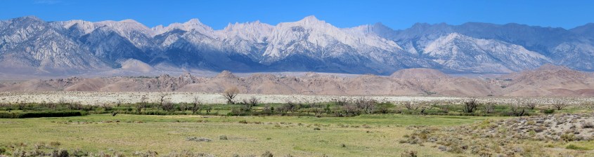
Just a correction: The picture at the top is not “looking east…at the desolate White Mountains.” You’re looking West at the Alabama Hills and the Sierra Nevada Mountains with Lone Pine Peak and Mount Whitney very visible.
Thank you, Christopher. I regret the error.
You’re welcomed. Thank you for fixing that.