Steve Kuchenski, a friend of the blog (as well as my friend!), suggested this podcast.
“Your regular readers may be familiar with much of this, but (for example) I was unaware of the original Fredrick Law Olmsted plan for parks all along the river in lieu of 100% concrete channelization,” he wrote in an email.
The description of this episode follows. If you would like to listen, >>CLICK HERE.
When you hear the word “river,” you probably picture a majestic body of water flowing through a natural habitat. Well, the LA River looks nothing like that. Most people who see it probably mistake it for a giant storm drain. It’s a deep trapezoidal channel with steep concrete walls, and a flat concrete bottom. Los Angeles was founded around this river. But decades ago it was confined in concrete so that, for better or worse, the city could become the sprawling metropolis that it is today. All these years later the county is still grappling with the consequences of those actions. Reported by Gillian Jacobs, guest hosted by 99PI producer, Vivian Le.
Many thanks to William Preston Bowling, Trout Unlimited South Coast chapter president, for these up close and personal videos of the majesty — and danger — of the LA when it rains.
With our seemingly never-ending drought, we need engineers to come up with a way to secure all this fresh rain water that’s racing out to the ocean, along with tons of trash.
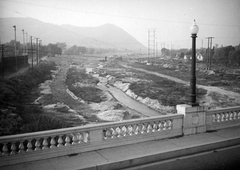
VIEW from the Glendale/Hyperion Bridge in 1937. (Courtesy LA Public Library)
UPDATE:
The barriers are going up now on east sidea of river. I was in the north Atwater park area and they are working their way south from Colorado Blvd. They have have made it to the park. Lights were being turned on and it didnt look like they were stopping for the night. Forget about any river access in that area!
I found this recent story that I saw on TV news as well as read in the L.A. Times pretty confusing. From the story:
“We’re hoping for the best, but we’re going to continue to prepare for the worst,” Los Angeles Mayor Eric Garcetti said. “… If [the river] floods, there is risk of significant damage, not to mention real and immediate danger to Angelenos.”
If you’ve been down to Glendale Narrows, you know that the river encasement is already high, 20 feet, according to the U.S. Army Corps Los Angeles River Ecosystem Restoration Feasibility Study so what could a temporary four-foot-high barrier accomplish that isn’t already there? And for $4.5 million?
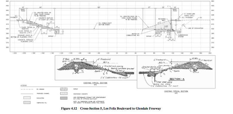
But the more vexing part of this emergency solution is “removing debris.” If the Corps removes the islands and plant life that dot the area, you can kiss the only structure fish have goodbye. It’s also a very healthy bird habitat. The NBC story indicates this is already taking place. Here’s the 2013 draft redesign plan for that area:
(U.S. Army Corps)
Existing Channel Features – The existing trapezoidal channel within the sub-reach varies from grouted rock to concrete paved channel, is 310 feet wide from the top of bank and 20 feet high from the invert.
Preliminary Channel Design – As seen in Figure 4.12, ” Cross-Section 5, Los Feliz Boulevard to Glendale Freeway,” the proposed design would construct four concrete terraced planters in the left/east bank of the channel slope. The right/west bank of the trapezoidal bank would be replaced by a 22-foot-high vertical retaining wall with subdrainage under the invert slab, which would meet the existing top of bank. Two riprap toedowns would be constructed below the channel bottom and bank. The first riprap toedown would be constructed on the right/west bank and the second that would include bank protection, would be located on the left/east bank. Two 16-foot-wide asphalt concrete maintenance roads would be constructed on the land of the retaining walls on the top of bank. The existing cobble/soft bottom would be protected in place and expanded 27 feet towards the proposed right/west bank of the channel.


The barriers are going up now on east sidea of river. I was in the north Atwater park area and they are working their way south from Colorado Blvd. They have have made it to the park. Lights were being turned on and it didnt look like they were stopping for the night. Forget about any river access in that area!